Difference between revisions of "Ogura Castle"
(XML import) |
|||
| Line 1: | Line 1: | ||
{{Castle | {{Castle | ||
| − | |English Name= | + | |English Name=Ogura Castle |
| − | + | |Japanese Name=小倉城 | |
| − | + | |Romaji Name=ogura-jo | |
| − | + | |Founder=Uesugi | |
| − | + | |Year Founded=late 1400s | |
| − | Ogura Castle | + | |Castle Type=Mountaintop |
| − | |Japanese Name= | + | |Castle Condition=Ruins only |
| − | 小倉城 | + | |Designations=Top 100 Mountaintop Castles, National Historic Site |
| − | |Romaji Name= | + | |Historical Period=Pre Edo Period |
| − | ogura-jo | + | |Features=stone walls |
| − | + | |Access=Musashi Ranzan Sta. (Tobu Tojo Line) or Myokaku Sta. (Yasaka Line); walk 1 hr | |
| − | + | |City=Tokigawa | |
| − | |Founder= | + | |Prefecture=Saitama Prefecture |
| − | Uesugi | + | |Notes=There are buses from each of the stations mentioned above that go near the castle, but they are few and far between and it is still about 1.5km from the nearest bus stop. At Daifukuji Temple there is a cemetary on it's right side. From the left side of the cemetary there is a very narrow path that looks like it's not even a path, that goes up behind the cemetery. It actually goes almost straight up the mountain to the castle ruins. From the top of the castle it looks like there might be other paths up from different places around the mountain but without any other maps or information this was the best I could find. See the temple and map pictures for more details. |
| − | |Year Founded= | + | |History=Some of the history of this castle is unclear. That could be the reason why most of my materials (including signs at the site) talk about the castle's structure more than its history. It was probably first founded when Ougigayatsu Uesugi controlled the area by his vassals the Ueda. When the Ueda moved to Matsuyama Castle, the Hojo stationed their vassal Tohyama at Ogura Castle. The Tohyama clan were close retainers of the Hojo and also ruled over Edo Castle for them. Ogura Castle became an important part of the Hojo's defensive plan extended towards the Chichibu area. Matsuyama Castle, Aotori Castle, Sugaya Castle, Ogura Castle, Aoyama Castle, and Koshigoe Castle make a straight line of defenses between the territories. Once this was thought to have been designed by the Hojo to mark out the edge of their territory but later excavations have shown that these castles were around since the Uesugi. The Hojo just took advantage of the them to fortify their network of castles. |
| − | late 1400s | ||
| − | |Castle Type= | ||
| − | Mountaintop | ||
| − | |Castle Condition= | ||
| − | Ruins only | ||
| − | |Designations= | ||
| − | National Historic Site | ||
| − | |Historical Period= | ||
| − | Pre Edo Period | ||
| − | |||
| − | |||
| − | |||
| − | |||
| − | |||
| − | |||
| − | |||
| − | |||
| − | |Features= | ||
| − | stone walls | ||
| − | |Access= | ||
| − | |||
| − | |||
| − | Musashi Ranzan Sta. (Tobu Tojo Line) or Myokaku Sta. (Yasaka Line); walk 1 hr | ||
| − | |||
| − | |||
| − | |||
| − | |||
| − | |||
| − | |||
| − | |||
| − | |||
| − | |City= | ||
| − | Tokigawa | ||
| − | |Prefecture= | ||
| − | Saitama Prefecture | ||
| − | |Notes= | ||
| − | |||
| − | |||
| − | There are buses from each of the stations mentioned above that go near the castle, but they are few and far between and it is still about 1.5km from the nearest bus stop. At Daifukuji Temple there is a cemetary on it's right side. From the left side of the cemetary there is a very narrow path that looks like it's not even a path, that goes up behind the cemetery. It actually goes almost straight up the mountain to the castle ruins. From the top of the castle it looks like there might be other paths up from different places around the mountain but without any other maps or information this was the best I could find. See the temple and map pictures for more details. | ||
| − | |||
| − | |||
| − | |History= | ||
| − | |||
| − | |||
| − | Some of the history of this castle is unclear. That could be the reason why most of my materials (including signs at the site) talk about the castle's structure more than its history. It was probably first founded when Ougigayatsu Uesugi controlled the area by his vassals the Ueda. When the Ueda moved to Matsuyama Castle, the Hojo stationed their vassal Tohyama at Ogura Castle. The Tohyama clan were close retainers of the Hojo and also ruled over Edo Castle for them. Ogura Castle became an important part of the Hojo's defensive plan extended towards the Chichibu area. Matsuyama Castle, Aotori Castle, Sugaya Castle, Ogura Castle, Aoyama Castle, and Koshigoe Castle make a straight line of defenses between the territories. Once this was thought to have been designed by the Hojo to mark out the edge of their territory but later excavations have shown that these castles were around since the Uesugi. The Hojo just took advantage of the them to fortify their network of castles. | ||
<p>Ogura Castle is a surprisingly well-fortified castle. It had significant stone walls when very few castles in this area had much stonework at all. It also sprawled across all three mountain ridges that join at this point with steep slopes on all sides and a river flowing along one side. It was a useful location to to watch the traffic on the Tokigawa River and continued the line of defenses from Sugaya Castle, but was unnecessarily well-fortified in the middle of the Hojo's defensive line and with Hachigata Castle just a bit farther away and the main front line fortification for the Hojo. One theory is that Ogura Castle was originally the front line defense for Ougigayatsu Uesugi and the Hojo just took advantage of it's fortifications for themselves despite the it's location. It's also odd that this mountain was chosen when it is actually much smaller than the surrounding ones. </p> | <p>Ogura Castle is a surprisingly well-fortified castle. It had significant stone walls when very few castles in this area had much stonework at all. It also sprawled across all three mountain ridges that join at this point with steep slopes on all sides and a river flowing along one side. It was a useful location to to watch the traffic on the Tokigawa River and continued the line of defenses from Sugaya Castle, but was unnecessarily well-fortified in the middle of the Hojo's defensive line and with Hachigata Castle just a bit farther away and the main front line fortification for the Hojo. One theory is that Ogura Castle was originally the front line defense for Ougigayatsu Uesugi and the Hojo just took advantage of it's fortifications for themselves despite the it's location. It's also odd that this mountain was chosen when it is actually much smaller than the surrounding ones. </p> | ||
| − | + | |Year Visited=2010 | |
| − | + | |Visits=November 11, 2010 | |
| − | |Visits= | + | |GPSLocation=36.03265, 139.2969 |
| − | November 11, 2010 | + | |rating_average=2.0 |
| − | | | + | |castleElev=130 |
| − | + | |ekiLatLng=36.044382,139.327743 | |
| − | + | |ekiElev=65 | |
| − | + | |elevChange=65 | |
| − | + | |kamon=uesugi.jpg | |
| − | + | |kamonFam=Uesugi | |
| − | + | |adminRating=2 | |
| − | + | |oldID=170 | |
| − | |rating_average= | ||
| − | 2.0 | ||
| − | |castleElev= | ||
| − | 130 | ||
| − | |ekiLatLng= | ||
| − | 36.044382,139.327743 | ||
| − | |ekiElev= | ||
| − | 65 | ||
| − | |elevChange= | ||
| − | 65 | ||
| − | |kamon= | ||
| − | uesugi.jpg | ||
| − | |kamonFam= | ||
| − | Uesugi | ||
| − | |adminRating= | ||
| − | 2 | ||
| − | |oldID= | ||
| − | 170 | ||
| − | |||
| − | |||
}} | }} | ||
Revision as of 22:31, 14 September 2017

History
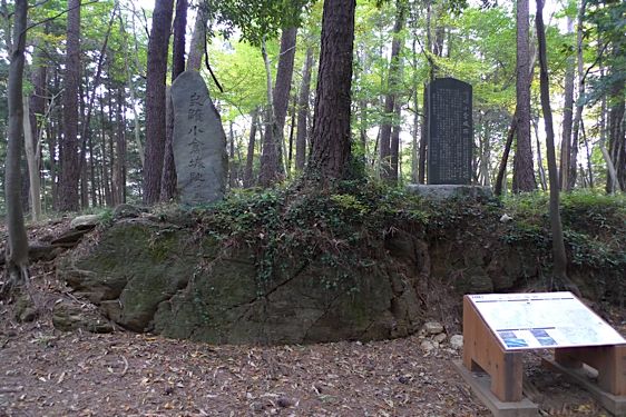
Some of the history of this castle is unclear. That could be the reason why most of my materials (including signs at the site) talk about the castle's structure more than its history. It was probably first founded when Ougigayatsu Uesugi controlled the area by his vassals the Ueda. When the Ueda moved to Matsuyama Castle, the Hojo stationed their vassal Tohyama at Ogura Castle. The Tohyama clan were close retainers of the Hojo and also ruled over Edo Castle for them. Ogura Castle became an important part of the Hojo's defensive plan extended towards the Chichibu area. Matsuyama Castle, Aotori Castle, Sugaya Castle, Ogura Castle, Aoyama Castle, and Koshigoe Castle make a straight line of defenses between the territories. Once this was thought to have been designed by the Hojo to mark out the edge of their territory but later excavations have shown that these castles were around since the Uesugi. The Hojo just took advantage of the them to fortify their network of castles.
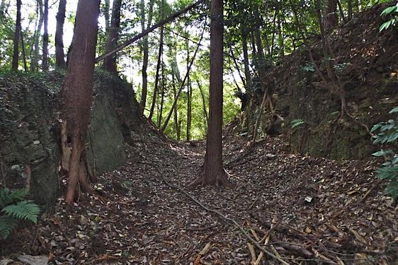
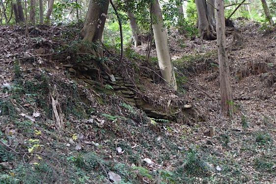
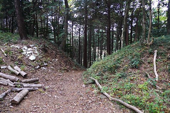
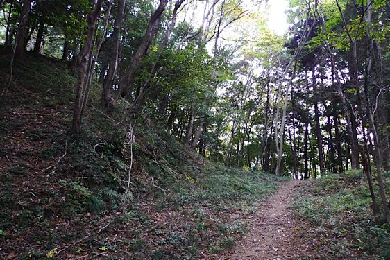
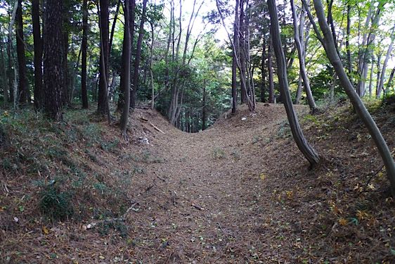
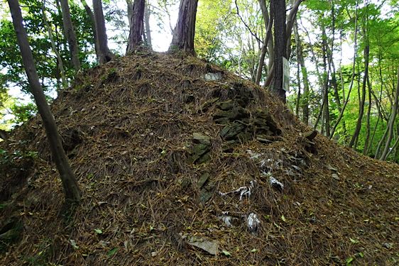
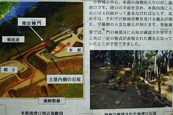
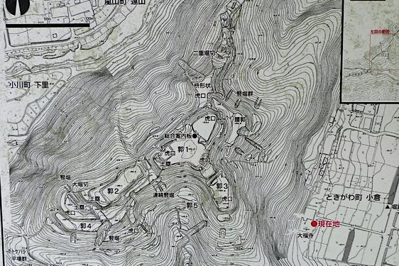
Ogura Castle is a surprisingly well-fortified castle. It had significant stone walls when very few castles in this area had much stonework at all. It also sprawled across all three mountain ridges that join at this point with steep slopes on all sides and a river flowing along one side. It was a useful location to to watch the traffic on the Tokigawa River and continued the line of defenses from Sugaya Castle, but was unnecessarily well-fortified in the middle of the Hojo's defensive line and with Hachigata Castle just a bit farther away and the main front line fortification for the Hojo. One theory is that Ogura Castle was originally the front line defense for Ougigayatsu Uesugi and the Hojo just took advantage of it's fortifications for themselves despite the it's location. It's also odd that this mountain was chosen when it is actually much smaller than the surrounding ones.
Visit Notes
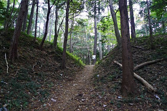
There are buses from each of the stations mentioned above that go near the castle, but they are few and far between and it is still about 1.5km from the nearest bus stop. At Daifukuji Temple there is a cemetary on it's right side. From the left side of the cemetary there is a very narrow path that looks like it's not even a path, that goes up behind the cemetery. It actually goes almost straight up the mountain to the castle ruins. From the top of the castle it looks like there might be other paths up from different places around the mountain but without any other maps or information this was the best I could find. See the temple and map pictures for more details.
Gallery


| Castle Profile | |
|---|---|
| English Name | Ogura Castle |
| Japanese Name | 小倉城 |
| Founder | Uesugi |
| Year Founded | late 1400s |
| Castle Type | Mountaintop |
| Castle Condition | Ruins only |
| Designations | Top 100 Mountaintop Castles, National Historic Site |
| Historical Period | Pre Edo Period |
| Features | stone walls |
| Visitor Information | |
| Access | Musashi Ranzan Sta. (Tobu Tojo Line) or Myokaku Sta. (Yasaka Line); walk 1 hr |
| Visitor Information | |
| Time Required | |
| Location | Tokigawa, Saitama Prefecture |
| Coordinates | 36° 1' 57.54" N, 139° 17' 48.84" E |
|
|
|
| Admin | |
| Added to Jcastle | |
| Admin Year Visited | 2010 |
| Admin Visits | November 11, 2010 |


Enable comment auto-refresher